tourinfra®

Show your guests the way
Online presence, mobile apps and traditional print media are by no means enough for successful outdoor destinations: The hardware must also be right in the field! Provide your information professionally on meaningful information boards and shine with trail signage that has been planned and implemented with care! We are happy to take on the installation of your initial signage, the revision and renewal of existing systems and the management of your signposting.
“Quality instead of quantity”: this is the guiding principle for reviewing and revising the existing network of paths, including sensitive areas, and optimizing the range to a realistic level. This requires comprehensive and sensitive planning processes in order to do justice to all interests and needs.
The advantages of tourinfra®
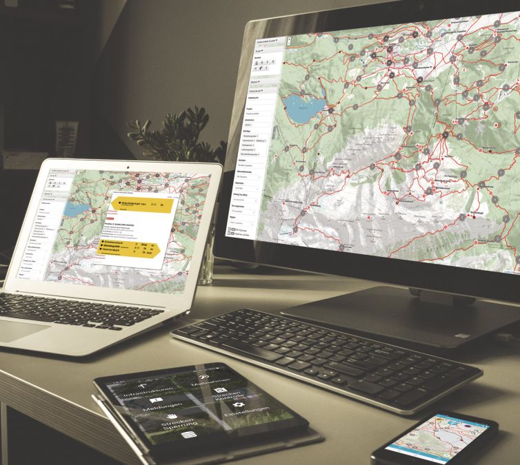
tourinfra® offers much more than other tour management systems. Only with us do you get the complete solution for your region. Tourinfra enables comprehensive management of your destination, starting with tour planning and management, through signage and infrastructure management, to the management of closures and the presentation of this data to guests in real time via a wide variety of channels and media.
- Web-based
- Scalable
- Expandable via modules
- Large number of interfaces
- Intuitive interface

Let us bring your vision to life.

In tourinfra®, tours for various sports can be created quickly and easily. Many tools and automatic functions support users in creating hiking, mountain biking and trail running tours, etc. The creation of routes using GPS data, off-road routing functions and automatic synchronization with map data from Open-Street-Map make work much easier. The tours can be provided with all kinds of important information for your guests. Intuitive media management and the integration of POIs and other information make creating tours child’s play.
The planning of these signage systems as well as the administration and maintenance are core functions of tourinfra®. Our system helps you with the planning and creation of signposting, from mileage to the automatic generation of signs and direct ordering from your service provider. The map views and search functions make it possible to manage even large destinations conveniently and intuitively.
Many destinations are facing similar challenges: on the one hand, they are getting bigger and bigger, on the other hand, there is less and less staff available. The solution to this dilemma: an end-to-end workflow from reporting the damage to recording the damage, taking measures to rectify the defects and handling the process. With tourinfra®, both the guest and the trail sponsors from the region can be flexibly integrated. With the associated route inspections, destinations also always have an overview of which route section needs to be inspected in the future.
So that you can inform your guests about the current route status at all times, tourinfra® has a closure system that alerts and warns of dangers in real time. In future, the system will automatically report closures based on sensor data (e.g. flooding sensors or rockfalls) and thus further increase the safety of your guests. In real time.
Wintermanager as a module in tourinfra enables destinations to present guests with a comprehensive winter report based on existing tour data and specific winter objects such as ski slopes, lifts and snow information. Data from the trail manager is transported to the guest in real time via various interfaces and output systems.


Route management module
In tourinfra®, tours for various sports can be created quickly and easily. Many tools and automatic functions support the user in creating hiking, mountain biking and trail running tours, etc. The creation of routes using GPS data, off-road routing functions and automatic synchronization with map data from Open-Street-Map make work much easier.
- Create or import tours
- Edit tour histories
- Maintaining tour characteristics
- Create media
- Controlling the media distribution of tours


Infrastructure module
Our system helps you with the planning and creation of signposting, starting with mileage and the automatic generation of signs through to direct ordering from your service provider. tourinfra® puts an end to endless searching in documents and Excel lists. Simply select the desired location on the map and all the information is clearly displayed.
- Web-based
- Scalable
- Expandable via modules
- Large number of interfaces
- Intuitive interface
Quality management module
An end-to-end workflow from reporting to recording the damage to the measures for rectifying the defects and processing. With tourinfra®, both guests and trail patrons from the region can be flexibly involved. With the associated route inspections, destinations also always have an overview of which route section needs to be inspected in the future. Logs and information can be conveniently recorded and passed on via the app during the inspection. The information on defects is managed centrally in tourinfra® and delegated from there to the construction yards and companies.
- Record messages decentrally
- Defect report for website
- Manage messages centrally
- Delegate tasks
- On-site processing via tourinfra mobil


Disruptions & Obstacles module
So that you can inform your guests about the current route status at all times, tourinfra® has a closure system that alerts and warns of dangers in real time. In future, the system will automatically report closures based on sensor data (e.g. flooding sensors or rockfalls) and thus further increase the safety of your guests. In real time.
- Create temporary locks
- Creation of detour
- Time-controlled lifting of locks
- Conflict avoidance through information on protected areas
- Construction site service


Print volumes

With tourinfra, print templates can be generated in a fully automated process. After filling in the content via the tourinfra interface, our customers are presented with a printable advertisement. These print templates can be sent directly to freely selectable print service providers.
A short video clip about the entire process of creating a cross-country ski trail sign.
100% made in Murnau in collaboration with our colleagues at Wiesendanger Medien


