tourinfra®mobile

Tourinfra mobile - working on site!
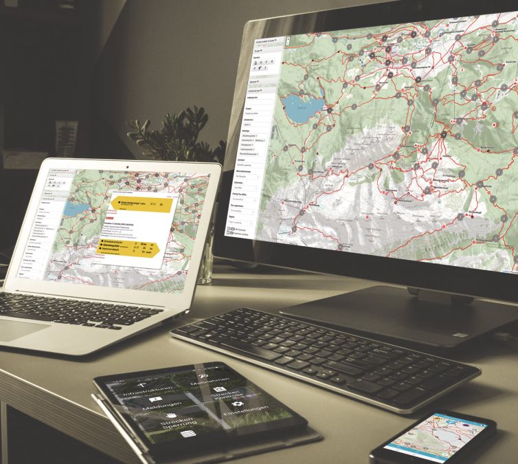
tourinfra® puts an end to endless searching in documents and Excel lists. Simply select the desired location on the map and all information on the local infrastructure is displayed clearly. And the best thing is: you can access all the information on your desktop screen via tourinfra®mobile in your pocket! And because tourinfra®mobile is 100% offline-capable, you always have all the data at hand, even in dense forests and narrow valleys. tourinfra® and tourinfra® mobil – it can be that easy!
The advantages of tourinfra®mobil
Tourinfra mobile is the ideal complement to the web solution and offers considerable savings potential in quality management. Compared to working with complex GIS systems, Excel spreadsheets or paper documents, it enables a more efficient and modern approach. The seamless data exchange between the systems and the intuitive operation make it easy to actively involve and inspire trail sponsors and associations in the processes.
- Seamless data exchange between tourinfra & tourinfra mobil
- Native app available for iOS & Android
- 100% offline capable
- Intuitive interface
- Focus on quality management
- Registration of new locations and infrastructures

Let us bring your vision to life.

Optimize your infrastructure on site: compare your database with reality, record new structures and document locations with photos and relevant information. This creates the basis for efficient planning on the desktop.
Defects can be documented and recorded via reports. Reports can also be checked in tourinfra mobil via the defect notifier.
Damage reports are rectified by means of measures. Measures can be optionally assigned. The processing can be documented with photos. Measures can be assigned via the defined work areas.
If you want to have your hiking trails or cycle paths checked continuously, then route checks are the right work area for you. The intervals can be freely defined as well as the length of the respective checks. If a route check is carried out, it is automatically marked as completed by the live tracking.
When route scouting, the route recording function allows you to record the routes you have taken and use them later as a basis for creating tours.


Registration of new infrastructures
Although tourinfra mobil focuses on quality management, the system also offers a first-class workflow for planning new infrastructure locations and digitizing existing structures. The user-friendly interface was specially developed for our customers and guarantees maximum ease of use. Complex, time-consuming and cost-intensive GIS training is not required to use the system.
- Creation of new locations
- Automatic position transfer
- Creation of photos
- Recording new infrastructures with an assistant
- Transmission of data after return
- Seamless further processing on the desktop


Tourinfra mobile in use for QM management
Tourinfra mobile is a practical addition for the quality management area in the Tourinfra software. Through synchronization, measures and messages are transferred based on individual user rights. On site, the app enables targeted filtering of information according to current needs. Details of the measures can be called up with one click and documented with a photo when the work is completed in order to adjust the status accordingly. In addition, new measures and reports can also be recorded directly on site, which significantly increases flexibility and efficiency in the work process. These functions make Tourinfra mobile a valuable tool for optimizing processes and documentation in quality management.
- Synchronize measures and messages
- Filter messages
- Process messages and measures
- Photo documentation of the work
- Link measures and messages directly to infrastructures
Further insights into tourinfra mobil
In addition to the areas of infrastructure, measures and messages, tourinfra mobil also includes the areas of route control, route closures, route recordings, data and settings.
In cooperation with clubs or trail sponsors, trail inspections enable the inspection of trails at freely definable intervals and sections. If live tracking is activated during the inspection, the inspection is automatically marked as completed. An inspection log can also be added.
If, for example, a tree is lying across the hiking trail, a trail closure can be activated directly on site. This blocking sets all affected tours that pass the blocked section to the status “blocked”.
Route recordings help to document the tested routes during scouting. The items can later be transferred to a tour in tourinfra.
The exchange between the app and the web is regulated in the data section. In addition, a map area can also be downloaded offline for navigation.
Personal working methods can be customized in the Settings area. The setting can also influence the map display.
- Sync settings between server and app
- Create route closures on site
- Process route controls
- Set photo sizes
- Record inspections and use them later as a tour


